
Portal:World
The World Portal


The world is the totality of entities, the whole of reality, or everything that exists. The nature of the world has been conceptualized differently in different fields. Some conceptions see the world as unique, while others talk of a "plurality of worlds". Some treat the world as one simple object, while others analyze the world as a complex made up of parts.
In scientific cosmology, the world or universe is commonly defined as "the totality of all space and time; all that is, has been, and will be". Theories of modality talk of possible worlds as complete and consistent ways how things could have been. Phenomenology, starting from the horizon of co-given objects present in the periphery of every experience, defines the world as the biggest horizon, or the "horizon of all horizons". In philosophy of mind, the world is contrasted with the mind as that which is represented by the mind.
Theology conceptualizes the world in relation to God, for example, as God's creation, as identical to God, or as the two being interdependent. In religions, there is a tendency to downgrade the material or sensory world in favor of a spiritual world to be sought through religious practice. A comprehensive representation of the world and our place in it, as is found in religions, is known as a worldview. Cosmogony is the field that studies the origin or creation of the world, while eschatology refers to the science or doctrine of the last things or of the end of the world.
In various contexts, the term "world" takes a more restricted meaning associated, for example, with the Earth and all life on it, with humanity as a whole, or with an international or intercontinental scope. In this sense, world history refers to the history of humanity as a whole, and world politics is the discipline of political science studying issues that transcend nations and continents. Other examples include terms such as "world religion", "world language", "world government", "world war", "world population", "world economy", or "world championship". (Full article...)
Selected articles -
-
 Global workforce refers to the international labor pool of workers, including those employed by multinational companies and connected through a global system of networking and production, foreign workers, transient migrant workers, remote workers, those in export-oriented employment, contingent workforce or other precarious work. As of 2012, the global labor pool consisted of approximately 3 billion workers, around 200 million unemployed. (Full article...)
 -

Map of Pangea around 250 million years ago, at the beginning of the Triassic
Pangaea or Pangea (/pænˈdʒiːə/ pan-JEE-ə) was a supercontinent that existed during the late Paleozoic and early Mesozoic eras. It assembled from the earlier continental units of Gondwana, Euramerica and Siberia during the Carboniferous approximately 335 million years ago, and began to break apart about 200 million years ago, at the end of the Triassic and beginning of the Jurassic. Pangaea was C-shaped, with the bulk of its mass stretching between Earth's northern and southern polar regions and surrounded by the superocean Panthalassa and the Paleo-Tethys and subsequent Tethys Oceans. Pangaea is the most recent supercontinent to have existed and the first to be reconstructed by geologists. (Full article...) -
World Heritage Memory Net (WHMNet), a partnership project with UNESCO World Heritage Centre, is a global digital library of cultural, historical, and heritage multimedia collections related to the current 962 UNESCO World Heritage Sites of 157 State Parties. Of these 962 sites, 745 are cultural sites, 188 natural, and 29 mixed and 38 of the total 962 are in danger. WHMNet was officially launched April 29, 2011, and can be thought of as “the world’s heritage at your fingertips.”
The guiding conceptual principle for the development of the World Heritage Memory Net is to construct a framework that allows users to easily see, explore, discover, and visually experience the 936 Heritage Sites first, and then dig in for more detailed and descriptive information about each Site, as graphically shown on the home page. It is directed by Ching-chih Chen, currently of Global Connection and Collaboration, a nonprofit and tax-exempt 501(c)(3) organization; prior to July 2010, Chen directed this project for three years at Simmons College until she became Professor Emeritus. (Full article...) -

The League of Nations (LN or LoN; French: Société des Nations [sɔsjete de nɑsjɔ̃], SdN) was the first worldwide intergovernmental organisation whose principal mission was to maintain world peace. It was founded on 10 January 1920 by the Paris Peace Conference that ended the First World War. The main organisation ceased operations on 18 April 1946 when many of its components were relocated into the new United Nations (UN) which was created in the aftermath of World War II. As the template for modern global governance, the League profoundly shaped the modern world.
The League's primary goals were stated in its eponymous Covenant. They included preventing wars through collective security and disarmament and settling international disputes through negotiation and arbitration. Its other concerns included labour conditions, just treatment of native inhabitants, human and drug trafficking, the arms trade, global health, prisoners of war, and protection of minorities in Europe. The Covenant of the League of Nations was signed on 28 June 1919 as Part I of the Treaty of Versailles, and it became effective with the rest of the Treaty on 10 January 1920. Australia was granted the right to participate as an autonomous member nation, marking the start of Australian independence on the global stage. The first meeting of the Council of the League took place on 16 January 1920, and the first meeting of the Assembly of the League took place on 15 November 1920. In 1919, U.S. president Woodrow Wilson won the Nobel Peace Prize for his role as the leading architect of the League. (Full article...) -
Around the World in Eighty Days (French: Le Tour du monde en quatre-vingts jours) is an adventure novel by the French writer Jules Verne, first published in French in 1872. In the story, Phileas Fogg of London and his newly employed French valet Passepartout attempt to circumnavigate the world in 80 days on a wager of £20,000 (equivalent to £2.3 million in 2023) set by his friends at the Reform Club. It is one of Verne's most acclaimed works. (Full article...) -
 Non-UN member states recognised by at least one UN member stateNon-UN member states recognised only by other non-UN member states or not recognized by any other state
A number of polities have declared independence and sought diplomatic recognition from the international community as sovereign states, but have not been universally recognised as such. These entities often have de facto control of their territory. A number of such entities have existed in the past.
There are two traditional theories used to indicate how a sovereign state comes into being. The declarative theory (codified in the 1933 Montevideo Convention) defines a state as a person in international law if it meets the following criteria: (Full article...) -

The Magellan-Elcano expedition was the first circumnavigation of the Earth.
Circumnavigation is the complete navigation around an entire island, continent, or astronomical body (e.g. a planet or moon). This article focuses on the circumnavigation of Earth.
The first circumnavigation of the Earth was the Magellan Expedition, which sailed from Sanlucar de Barrameda, Spain in 1519 and returned in 1522, after crossing the Atlantic, Pacific, and Indian oceans. Since the rise of commercial aviation in the late 20th century, circumnavigating Earth is straightforward, usually taking days instead of years. Today, the challenge of circumnavigating Earth has shifted towards human and technological endurance, speed, and less conventional methods. (Full article...)

.png)
.svg)


General images -
-
 Artist's conception of Devonian flora (from History of Earth)
 -
 Empires of the world in 1898
 -
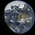
 A view of Earth with its global ocean and cloud cover, which dominate Earth's surface and hydrosphere; at Earth's polar regions, its hydrosphere forms larger areas of ice cover. (from Earth)
 -

-
 Graph showing range of estimated partial pressure of atmospheric oxygen through geologic time (from History of Earth)
 -
 Vitruvian Man by Leonardo da Vinci epitomizes the advances in art and science seen during the Renaissance. (from History of Earth)
 -
 A banded iron formation from the 3.15 Ga Moodies Group, Barberton Greenstone Belt, South Africa. Red layers represent the times when oxygen was available; gray layers were formed in anoxic circumstances. (from History of Earth)
 -
 Successive dispersals of Homo erectus (yellow), Homo neanderthalensis (ochre) during Out of Africa I and Homo sapiens (red, Out of Africa II), with the numbers of years since they appeared before present. (from Human history)
 -
 Chloroplasts in the cells of a moss (from History of Earth)
 -
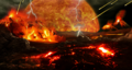
 Artist's conception of Hadean Eon Earth, when it was much hotter and inhospitable to all forms of life. (from History of Earth)
 -
 Cuneiform inscription, eastern Turkey
 -
 Artist's impression of the enormous collision that probably formed the Moon (from History of Earth)
 -
 Artist's rendition of an oxinated fully-frozen Snowball Earth with no remaining liquid surface water. (from History of Earth)
 -
-
 Standing Buddha from Gandhara, 2nd century CE
 -
 Earth's land use for human agriculture in 2019 (from Earth)
 -
 Portrait of Alfraganus in the Compilatio astronomica, 1493. Islamic astronomers began just before the 9th century to collect and translate Indian, Persian and Greek astronomical texts, adding their own astronomy and enabling later, particularly European astronomy to build on. Symbolic for the post-classical period, a period of an increasing trans-regional literary culture, particularly in the sciences, spreading and building on methods of science. (from Human history)
 -
 Olmec colossal head, now at the Museo de Antropología de Xalapa
 -
 The replicator in virtually all known life is deoxyribonucleic acid. DNA is far more complex than the original replicator and its replication systems are highly elaborate. (from History of Earth)
 -
 Tracy Caldwell Dyson, a NASA astronaut, observing Earth from the Cupola module at the International Space Station on 11 September 2010 (from Earth)
 -
 A composite image of artificial light emissions at night on a map of Earth (from Earth)
 -
 One of the eleven Rock-hewn Churches of Lalibela constructed during the Zagwe dynasty in Ethiopia (from Human history)
 -
 A reconstruction of Pannotia (550 Ma). (from History of Earth)
 -

-
 Image of the physical world, captured by the Hubble Space Telescope (from World)
 -
 European migrations by mostly Germanic peoples, 2nd–6th centuries (from Human history)
 -
 Cross-section through a liposome (from History of Earth)
 -

-

-

-
 13th-century French historiated initial with the three classes of medieval society: those who prayed (the clergy), those who fought (the knights), and those who worked (the peasantry)
 -
 Satellite time lapse imagery of Earth's rotation showing axis tilt (from Earth)
 -
 Tiktaalik, a fish with limb-like fins and a predecessor of tetrapods. Reconstruction from fossils about 375 million years old. (from History of Earth)
 -
 Pale orange dot, an artist's impression of Early Earth, featuring its tinted orange methane-rich early atmosphere (from Earth)
 -

-
 An artist's impression of ice age Earth at glacial maximum. (from History of Earth)
 -
 Shanghai. China urbanized rapidly in the 21st century.
 -
 Carving of Persian and Median soldiers, Persepolis, Achaemenid Empire, 5th century BCE
 -
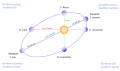
 Yggdrasil, an attempt to reconstruct the Norse world tree which connects the heavens, the world, and the underworld. (from World)
 -
 A map of heat flow from Earth's interior to the surface of Earth's crust, mostly along the oceanic ridges (from Earth)
 -

-
 Battle during the 1281 Mongol invasion of Japan
 -
 Lithified stromatolites on the shores of Lake Thetis, Western Australia. Archean stromatolites are the first direct fossil traces of life on Earth. (from History of Earth)
 -
 Dinosaurs were the dominant terrestrial vertebrates throughout most of the Mesozoic (from History of Earth)
 -
 Taj Mahal, Mughal Empire, India
 -
 Artist's impression of Earth during the later Archean, the largely cooled planetary crust and water-rich barren surface, marked by volcanoes and continents, features already round microbialites. The Moon, still orbiting Earth much closer than today and still dominating Earth's sky, produced strong tides. (from History of Earth)
 -

-
 Change in average surface air temperature and drivers for that change. Human activity has caused increased temperatures, with natural forces adding some variability. (from Earth)
 -

-
 Last Moon landing: Apollo 17 (1972)
 -

-

-
 An artist's rendering of a protoplanetary disk (from History of Earth)
 -
 A view of Earth with different layers of its atmosphere visible: the troposphere with its clouds casting shadows, a band of stratospheric blue sky at the horizon, and a line of green airglow of the lower thermosphere around an altitude of 100 km, at the edge of space (from Earth)
 -
 The first airplane, the Wright Flyer, flew on 17 December 1903.
 -
 Geologic map of North America, color-coded by age. From most recent to oldest, age is indicated by yellow, green, blue, and red. The reds and pinks indicate rock from the Archean.
 -
 Machu Picchu, Inca Empire, Peru
 -
 Great Pyramids of Giza, Egypt
 -
 A composite image of Earth, with its different types of surface discernible: Earth's surface dominating Ocean (blue), Africa with lush (green) to dry (brown) land and Earth's polar ice in the form of Antarctic sea ice (grey) covering the Antarctic or Southern Ocean and the Antarctic ice sheet (white) covering Antarctica. (from Earth)
 -
 Pillar erected by Ashoka, a Mauryan Emperor in India
 -
 Benin Bronze head from Nigeria
 -
 COVID-19 pandemic, 2020 (from Human history)
 -

-
An artist's impression of the Archean, the eon after Earth's formation, featuring round stromatolites, which are early oxygen-producing forms of life from billions of years ago. After the Late Heavy Bombardment, Earth's crust had cooled, its water-rich barren surface is marked by continents and volcanoes, with the Moon still orbiting Earth half as far as it is today, appearing 2.8 times larger and producing strong tides. (from Earth)
-
 Model of a Australopithecus afarensis at the Smithsonian National Museum of Natural History. This reconstruction depicts the facultative bipedalism hypothesis, indicated by the use of the tree for stabilization. (from Human history)
 -
 Earth's western hemisphere showing topography relative to Earth's center instead of to mean sea level, as in common topographic maps (from Earth)
 -
 Pangaea was a supercontinent that existed from about 300 to 180 Ma. The outlines of the modern continents and other landmasses are indicated on this map. (from History of Earth)
 -
 Ming dynasty section, Great Wall of China
 -
 A 2012 artistic impression of the early Solar System's protoplanetary disk from which Earth and other Solar System bodies were formed (from Earth)
 -
 Notre-Dame de Paris, France
 -
 Earth's night-side upper atmosphere appearing from the bottom as bands of afterglow illuminating the troposphere in orange with silhouettes of clouds, and the stratosphere in white and blue. Next the mesosphere (pink area) extends to the orange and faintly green line of the lowest airglow, at about one hundred kilometers at the edge of space and the lower edge of the thermosphere (invisible). Continuing with green and red bands of aurorae stretching over several hundred kilometers. (from Earth)
 -
The pale orange dot, an artist's impression of the early Earth which might have appeared orange through its hazy methane rich prebiotic second atmosphere. Earth's atmosphere at this stage was somewhat comparable to today's atmosphere of Titan. (from History of Earth)
-
 Chennakesava Temple, Belur, India
 -
 Earth's axial tilt causing different angles of seasonal illumination at different orbital positions around the Sun (from Earth)
 -
 Earth's history with time-spans of the eons to scale. Ma means "million years ago". (from History of Earth)
 -
 A 580 million year old fossil of Spriggina floundensi, an animal from the Ediacaran period. Such life forms could have been ancestors to the many new forms that originated in the Cambrian Explosion. (from History of Earth)
 -
 Angkor Wat temple complex, Cambodia, early 12th century
 -
 A computer-generated image mapping the prevalence of artificial satellites and space debris around Earth in geosynchronous and low Earth orbit (from Earth)
 -
 A pillar at Neolithic Göbekli Tepe
 -
 A schematic view of Earth's magnetosphere with solar wind flowing from left to right (from Earth)
 -
 A reconstruction of human history based on fossil data. (from History of Earth)
 -
 Florence, birthplace of the Italian Renaissance
 -
 Japanese depiction of a Portuguese carrack, a result of globalizing maritime trade
 -
 Obelisk of Axum, Ethiopia
 -
 Fall of the Berlin Wall, 1989
 -
 Trilobites first appeared during the Cambrian period and were among the most widespread and diverse groups of Paleozoic organisms. (from History of Earth)
 -
 An animation of the changing density of productive vegetation on land (low in brown; heavy in dark green) and phytoplankton at the ocean surface (low in purple; high in yellow) (from Earth)
 -
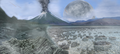
 Artist's impression of a Hadean landscape with the relatively newly formed Moon still looming closely over Earth and both bodies sustaining strong volcanism. (from History of Earth)


.jpg)


.png)


.jpeg)


.svg)


.jpg)


Megacities of the world -

Kinshasa (/kɪnˈʃɑːsə/; French: [kinʃasa]; Lingala: Kinsásá), formerly named Léopoldville from 1881–1966, is the capital and largest city of the Democratic Republic of the Congo. Kinshasa is one of the world's fastest-growing megacities, with an estimated population of 17,032,322 in 2024. It is the most densely populated city in the DRC, the most populous city in Africa, the world's fourth-most-populous capital city, Africa's third-largest metropolitan area, the world's twenty-second most populous city and the leading economic, political, and cultural center of the DRC. Kinshasa houses several industries, including manufacturing, telecommunications, banking, and entertainment. The city also hosts some of DRC's significant institutional buildings, such as the People's Palace, Palace of the Nation, Court of Cassation, Constitutional Court, African Union City, Marble Palace, Martyrs Stadium, Government House, Kinshasa Financial Center, and other national departments and agencies.
Covering 9,965 square kilometers, Kinshasa stretches along the southern shores of the Pool Malebo on the Congo River. It forms an expansive crescent across flat, low-lying terrain at an average altitude of about 300 meters. Situated between latitudes 4° and 5° and longitudes East 15° and 16°32, Kinshasa shares its borders with the Mai-Ndombe Province, Kwilu Province, and Kwango Province to the east; the Congo River delineates its western and northern perimeters, constituting a natural border with the Republic of the Congo; to the south lies the Kongo Central Province. Across the river sits Brazzaville, the smaller capital of the neighboring Republic of the Congo, forming the world's second-closest pair of capital cities despite being separated by a four-kilometer-wide unbridged span of the Congo River. (Full article...)
Did you know -

- ... that a Florida radio station DJ's attempt to break a world record was foiled by blown transmitter tubes?
- ... that Bill Hatfield, the oldest person to have sailed solo around the world, had previously narrowly survived a shipwreck with his young family?
- ... that some British soldiers hung the First World War propaganda poster "Daddy, what did you do in the Great War?" in the trenches and left sarcastic answers to the daughter's question?
- ... that at the age of 19, Van E. Chandler was the youngest pilot in the United States Armed Forces to become a flying ace during World War II?
- ... that John Bennet Lawes started producing superphosphate, the first chemical manure produced in the world, from fossilised dinosaur dung on an industrial scale?
- ... that Melissa Clark-Reynolds, who was awarded the Insignia of an Officer of the New Zealand Order of Merit, developed the now-defunct virtual world MiniMonos?
- ... that Polish prisoners of war in World War II were held not only by Nazi Germany but also by the Soviet Union?
- ... that the relatively low death toll of 100 of the 1997 Bojnurd earthquake was attributed to a foreshock and most residents being outdoors?
Countries of the world -

Palestine, officially the State of Palestine, is a country in the Southern Levant region of West Asia. Recognized by a majority of UN member states, it encompasses the Israeli-occupied West Bank, including East Jerusalem, and the Gaza Strip, collectively known as the occupied Palestinian territories, within the broader geographic and historical Palestine region. Palestine shares most of its borders with Israel, and it borders Jordan to the east and Egypt to the southwest. It has a total land area of 6,020 square kilometres (2,320 sq mi) while its population exceeds five million people. Its proclaimed capital is Jerusalem, while Ramallah serves as its administrative center. Gaza City was its largest city prior to evacuations in 2023.
Situated at a continental crossroad, the region of Palestine was ruled by various empires and experienced various demographic changes from antiquity to the modern era. Being a bridge between Asia and Africa, it was treading ground for the Nile and Mesopotamian armies and merchants from North Africa, China and India. The region is known for its religious significance. The ongoing Israeli–Palestinian conflict dates back to the rise of the Zionist movement, supported by the United Kingdom during World War I. The war saw Britain occupying Palestine from the Ottoman Empire, where it set up Mandatory Palestine under the auspices of the League of Nations. Increased Jewish immigration led to intercommunal conflict between Jews and Palestinian Arabs, which escalated into a civil war in 1947 after a proposed partitioning by the United Nations was rejected by the Palestinians. (Full article...)
The 12 Treasures of Spain (Spanish: 12 Tesoros de España) was a project that selected the purported "Twelve Treasures of the Kingdom of Spain". The contest was conducted by broadcasters Antena 3 and COPE. The final results were announced on 31 December 2007. Nine architectural monuments, two natural monuments and a monument pictorial were chosen. (Full article...)
Related portals
Protected areas of the world -
-
-

Bonampak is an ancient Maya archaeological site in the Mexican state of Chiapas, and is a natural monument.
There are currently 232 Protected Natural Areas in Mexico, covering 98 million hectares in total. They are protected and administered by the National Commission of Protected Natural Areas (Comisión Nacional de Áreas Naturales Protegidas, or 'CONANP'), a federal agency under the Secretariat of Environment and Natural Resources (SEMARNAT). CONANP administers:- 79 Mexican National Parks
- 48 biosphere reserves
- 57 flora and fauna protection areas
- 28 Mexican Nature Sanctuaries
- 15 natural resources protection areas
- 5 natural monuments
-
This list of protected areas of Quebec includes federally, provincially and municipally administered parks and wildlife reserves in Quebec, the largest province in Canada. (Full article...) -
Protected areas of Canada consist of approximately 12.1 percent of the nation's landmass and freshwater are considered conservation areas, including 11.4 percent designated as protected areas. Approximately 13.8 percent of Canada's territorial waters are conserved, including 8.9 percent designated as protected areas. Terrestrial areas conserved have increased by 65 percent in the 21st century, while marine areas conserved have increased by more than 3,800 percent.
Conservation and protected areas have different mandates depending on the organization which manages them, with some areas having a greater focus on ecological integrity, historical preservation, public usage, scientific research, or a combination of usages. Some areas such as the Polar Bear Pass, are co-managed and overseen by government and local indigenous agencies. (Full article...) -
This is a list of protected areas of Sierra Leone, including national parks, game reserves, conservation areas, wetlands, and those that are listed as proposed protected areas in the UN Environment Programme World Conservation Monitoring Centre (UNEP WCM) database. (Full article...)
-
Bihar is a state in East India. It is bounded by Uttar Pradesh to the west, Nepal to the north, West Bengal to the east and Jharkhand to the south. About 7% of the state is protected forest area. (Full article...)
-

Upolu Island, Samoa
This is a list of some protected areas of Samoa which include national parks, reservations, protected nature zones, marine reserves and other areas of significant biodiversity and conservation.
In 1994, Samoa ratified the international and legally binding treaty, the Convention on Biological Diversity to develop national strategies for conservation and sustainable use of biological diversity. In 2010, protected areas in the country cover 5% of land although the government aims to increase protected areas coverage to 15%. (Full article...) -

Grand Canyon of Yellowstone
The protected areas of the United States are managed by an array of different federal, state, tribal and local level authorities and receive widely varying levels of protection. Some areas are managed as wilderness, while others are operated with acceptable commercial exploitation. As of 2022[update], the 42,826 protected areas covered 1,235,486 km2 (477,024 sq mi), or 13 percent of the land area of the United States. This is also one-tenth of the protected land area of the world. The U.S. also had a total of 871 National Marine Protected Areas, covering an additional 1,240,000 sq mi (3,200,000 km2), or 26 percent of the total marine area of the United States. (Full article...) -
This is a list of the nationally designated protected areas of China. There are many forms of protected areas in China. Based on their relative importance, each type of protected area can be further graded into two to three levels (national, provincial and prefectural/county level). Nevertheless, the highest rank for "pocket nature preserve" (social and mass-based), "no-hunting area", "no-fishing area", "no-logging area", "wild medicinal material resources conservation area", "crop germplasm resources conservation area", "forest tree germplasm resources conservation area" or "source water protection area" is practically restricted to provincial level. The local government at county level is also responsible for the delimitation and declaration of "basic farmland protection area" and "basic grassland".
Take note that many protected areas in China have multiple official designations, and the statutory boundaries of these multi-designated PAs may be identical or may vary one from the other. For instance, the boundaries of Huangshan NSHA coincide with those of the Huangshan NGP, whereas Fujian province's Wuyi Mountains NNR, NSHA and NFP are adjacent to each other. In Heilongjiang, 27,642.14 hectares out of 115,340.27 hectares of Huzhong NFP are intersected with the experiment zone of Huzhong NNR. (Full article...) -
Protected areas of Slovenia include one national park (Slovene: narodni park), three regional parks (regijski park), several natural parks (krajinski park), and hundreds of natural monuments (naravni spomenik) and monuments of designed nature (spomenik oblikovane narave). They cover about 12.5% of the Slovenian territory. Under the Wild Birds Directive, 26 sites totalling roughly 25% of the nation's land are "Special Protected Areas"; the Natura 2000 proposal would increase the totals to 260 sites and 32% of national territory. (Full article...)
-
Kentucky's system of 44 state parks has been referred to as "the nation's finest" and experiences more repeat business annually than those of any other U.S. state. The state's diverse geography provides a variety of environments to experience. From mountain lakes to expansive caves to forests teeming with wildlife, park-goers have their choice of attractions, and they are all within a day's drive of each other.
Unless otherwise specified, data in the following lists are taken from Kentucky State Parks by Bill Bailey. (Full article...) -
Protected areas of the European Union are areas which need and/or receive special protection because of their environmental, cultural or historical value to the member states of the European Union.
(Full article...) -
The protected areas of Finland include national parks, nature reserves and other areas, with a purpose of conserving areas of all of Finland's ecosystems and biotopes.
Protected areas include:- National parks of Finland (Kansallispuisto/Nationalpark) – 8,170 km2
- Strict nature reserves of Finland (Luonnonpuisto/Naturreservat) – 1,530 km2
- Mire reserves of Finland (Soidensuojelualue/Myrskyddsområde) – 4,490 km2
- Protected herb-rich forest areas (Lehtojensuojelualue/Lundskyddsområde) – 13 km2
- Protected old-growth forest areas (Vanhat metsät/Gamla skogar) – 100 km2
- Grey seal protection areas (Hylkeidensuojelualue/Sälskyddsområde) – 190 km2
- Other protected areas on state-owned land – 468 km2
-
Protected areas of Slovakia are areas that need protection because of their environmental, historical or cultural value to the nation. Protected areas in Slovakia are managed by institutions and organizations governed by the Ministry of the Environment.
Types of protected areas:- National Park (Slovak: Národný park; abbr. NP)
- Protected Landscape Area (Chránená krajinná oblasť; CHKO)
- National Nature Reserve (Národná prírodná rezervácia; NPR)
- Nature Reserve (Prírodná rezervácia; PR)
- National Nature Monument (Národná prírodná pamiatka; NPP)
- Nature Monument (Prírodná pamiatka; PP)
- Protected Site (Chránený areál; CHA)
- Protected Landscape Element (Chránený krajinný prvok; CHKP)
- Protected Bird Area* (Chránené vtáčie územie; CHVÚ) *Technically Special Protection Area (SPA) under the EU Bird's Directive
- Protected Tree (Chránený strom; CHS)
-


Selected world maps
-
 1516 map of the world by Martin Waldseemüller
 -
 The world map by Gerardus Mercator (1569), the first map in the well-known Mercator projection
 -
 A plate tectonics map with volcano locations indicated with red circles
 -
 United Nations Human Development Index map by country (2016)
 -
 Index map from the International Map of the World (1:1,000,000 scale)
 -
 The Goode homolosine projection is a pseudocylindrical, equal-area, composite map projection used for world maps.
 -
 Only a few of the largest large igneous provinces appear (coloured dark purple) on this geological map, which depicts crustal geologic provinces as seen in seismic refraction data
 -
 Time zones of the world
 -
 Mollweide projection of the world


World records
- List of Olympic records in athletics
- List of world records in athletics
- List of junior world records in athletics
- List of world records in masters athletics
- List of world youth bests in athletics
- List of IPC world records in athletics
- List of world records in canoeing
- List of world records in chess
- List of cycling records
- List of world records in track cycling
- List of world records in finswimming
- List of world records in juggling
- List of world records in rowing
- List of world records in speed skating
- List of world records in swimming
- List of IPC world records in swimming
- List of world records in Olympic weightlifting
Topics

Continents of Earth | ||||||||
|---|---|---|---|---|---|---|---|---|
| ||||||||
| ||||||||
| ||||||||


| Cenozoic Era (present–66.0 Ma) |
| ||||||||||||
|---|---|---|---|---|---|---|---|---|---|---|---|---|---|
| Mesozoic Era (66.0–252 Ma) |
| ||||||||||||
| Paleozoic Era (252–539 Ma) |
| ||||||||||||
| Proterozoic Eon (539 Ma–2.5 Ga) |
| ||||||||||||
| Archean Eon (2.5–4 Ga) | |||||||||||||
| Hadean Eon (4–4.6 Ga) | |||||||||||||
ka = kiloannum (thousand years ago); Ma = megaannum (million years ago); Ga = gigaannum (billion years ago). See also: Geologic time scale • | |||||||||||||
| Locations | ||
|---|---|---|
| Related | ||

| |||||||||||||||||||
| |||||||||||||||||||
| |||||||||||||||||||
Economic classification of countries | |||||
|---|---|---|---|---|---|
| Three-World Model | |||||
| Gross domestic product (GDP) |
| ||||
| Gross national income (GNI) | |||||
| Wages | |||||
| Wealth | |||||
| Other national accounts | |||||
| Human development | |||||
| Digital divide | |||||
| Net international investment position (NIIP) | |||||
| Technological |
| ||||
|---|---|---|---|---|---|
| Sociological | |||||
| Ecological |
| ||||
| Biological |
| ||||
| Astronomical | |||||
| Eschatological |
| ||||
| Others |
| ||||
| Fictional | |||||
| Organizations | |||||
Categories

Wikimedia
The following Wikimedia Foundation sister projects provide more on this subject:
-
 Commons
Free media repository -
 Wikibooks
Free textbooks and manuals -
 Wikidata
Free knowledge base -
 Wikinews
Free-content news -
 Wikiquote
Collection of quotations -
 Wikisource
Free-content library -
 Wikispecies
Directory of species -
 Wikiversity
Free learning tools -
 Wikivoyage
Free travel guide -
 Wiktionary
Dictionary and thesaurus


